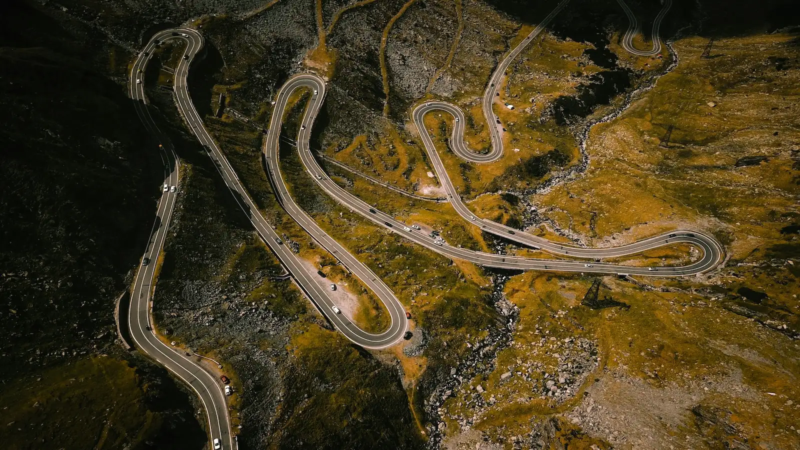
Endless switchbacks climbing to Bâlea Lake at 2,042 meters. Romania's most famous road, and it earns every bit of the hype.
By Cristi Roșu, co-founder · Updated 12 September 2026
The Transfăgărășan (DN7C) at a Glance
The Transfăgărășan Highway is the ride that put Romania on the motorcycle map. Built by Ceaușescu in the 1970s as a military road, it cuts straight through the Făgăraș Mountains, the highest range in Romania, with over 800 meters of altitude gain in tight, relentless switchbacks. At the top: Bâlea Lake, sitting at 2,042m, surrounded by glacial cirques and snow patches well into July.
But the road is only the centrepiece. Our multi-day loop from Cluj-Napoca connects Sibiu, the Olt Valley and the southern approach through Curtea de Argeș, and how you come home depends on the days you have: straight back to Cluj through Sibiu, or over the Transalpina and then through the Apuseni on secondary roads. The route mixes fast sweeping tarmac, high-altitude passes, and optional gravel detours through shepherd villages that most tourists never see.
The high section over Bâlea opens only for the warm months, late June to October in a normal year, and early starts beat the tourist traffic to the summit.
Route Facts
RoadDN7C, Curtea de Argeș to Cârțișoara
Length151 km end to end, about 90 km of mountain
TopBâlea Lake, 2,042 m
OpenMid-June to late October, 07:00 to 21:00
Last fuelDN1 before the Cârțișoara turn-off (north), Curtea de Argeș (south)
From Cluj-NapocaAbout 250 km via Sibiu
Riding the Transfăgărășan
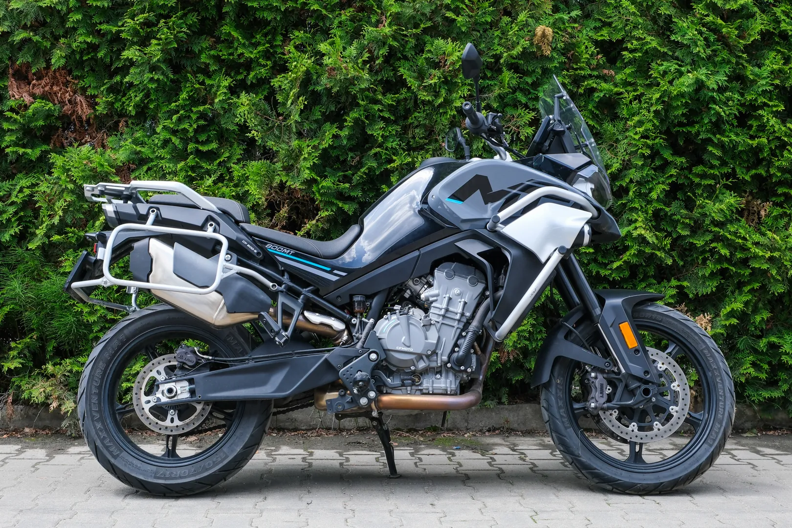
Top Gear called it "the best road in the world" in 2009, and every summer since, people have crossed a continent to ride it, by motorbike more than any other way. We run an adventure motorcycle rental fleet in Cluj-Napoca, a few hours north of the pass, and we send riders over it all season. This is the briefing we give them: when the road is actually open, which direction to ride it, where the last fuel is, and the things nobody warns you about.
What the Transfăgărășan Actually Is
On the map it's the DN7C, a national road built between 1970 and 1974 on Ceaușescu's orders (crazy that it only took four years back then). After the Soviet invasion of Czechoslovakia in 1968, he wanted a military route straight across the mountains, so the army blasted one through the Făgăraș, the highest range in Romania. The full DN7C runs 151 km from Bascov, near Pitești, to the DN1 in the north, but the part everyone means is the mountain section of roughly 90 km between the Vidraru dam and Cârțișoara, carried on 27 bridges and viaducts and through a tunnel just under a kilometre long.
The road tops out at 2,042 m beside Bâlea Lake, which makes it Romania's second highest paved road. The highest is the Transalpina at 2,145 m, and we have a free guide for that one too. Ride both and you'll notice they're different animals: the Transalpina stays high and open for hours, while the Transfăgărășan compresses everything into one steep, theatrical climb and descent.
The Transfăgărășan by the Numbers
151 km of DN7C end to end, Bascov to the DN1. About 90 km of it is the mountain.
2,042 m at Bâlea Lake, the second highest paved road in Romania after the Transalpina.
About 885 m of tunnel under the ridge at the top, the longest road tunnel in the country.
5 tunnels, 27 viaducts and about 830 small bridges along the way.
6,000 tonnes of dynamite and four years of work, 1970 to 1974. Opened on 20 September 1974.
40 soldiers died building it by the official count. The men who built it say many more.
About 68 m of waterfall at Bâlea Cascadă, at the foot of the switchbacks.
An ice hotel rebuilt on Bâlea Lake every winter, December to April, when the road below it is shut.
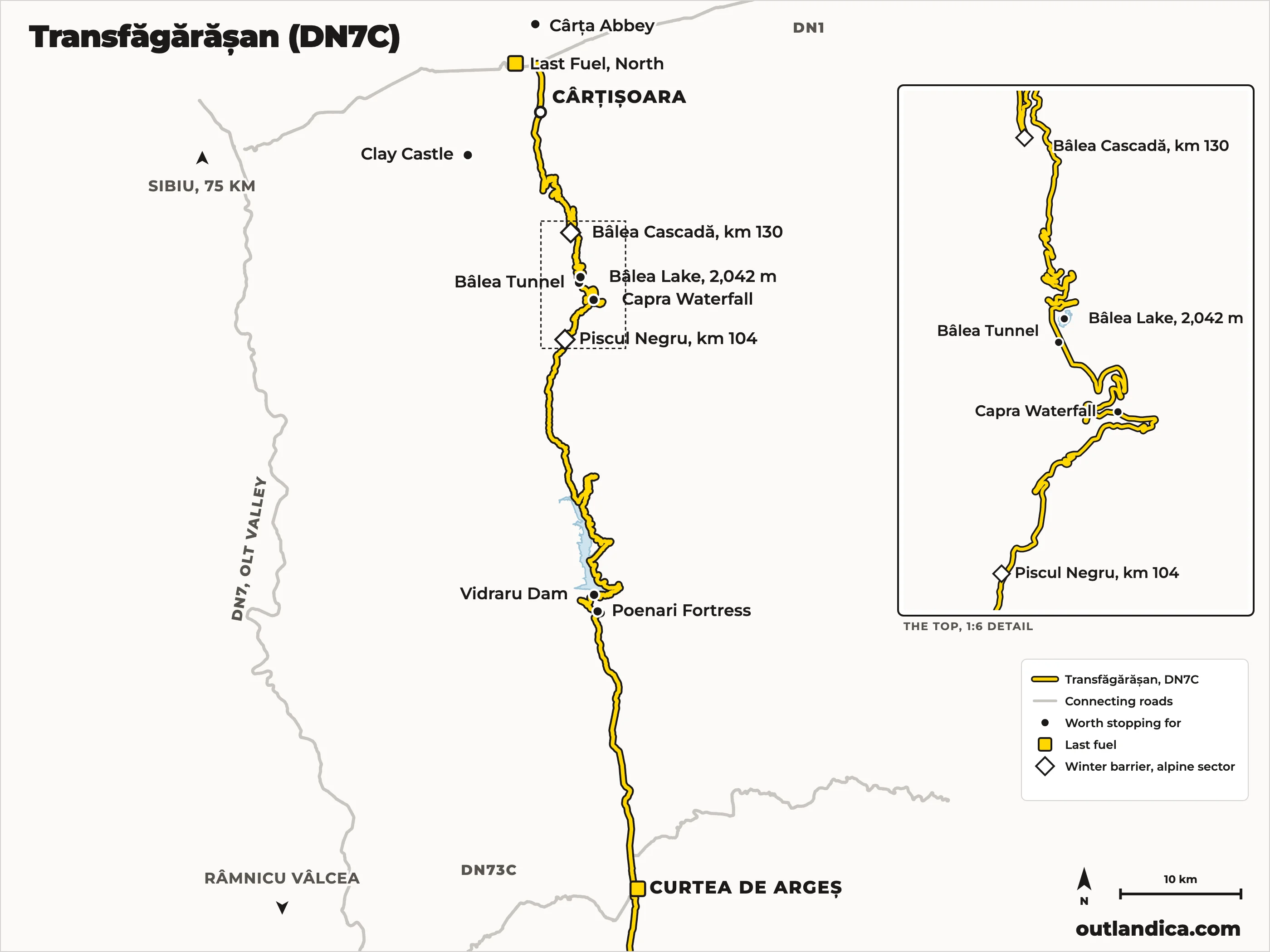
South to north, the way we ride it: Curtea de Argeș, Poenari, the dam, the lake, the tunnel, the switchbacks down to Cârțișoara. Open the route in Google Maps for turn-by-turn on your phone.
When Is the Transfăgărășan Actually Open
This is the question that ruins trips, so get it right. The alpine sector, between Piscul Negru (km 104) on the south side and Bâlea Cascadă (km 130+800) on the north side, closes every winter. There is no fixed reopening date: a CNAIR commission inspects the road each June and opens it when the snow walls, avalanche risk and rockfall allow. In 2025 it opened on 6 June; in 2026 on 12 June, and even that slipped three hours on the morning itself, when an orange warning for torrential rain forced one more inspection. The seasonal closure usually comes in the second half of October; in 2025 the barriers dropped on 20 October.
Two more things riders miss. First, even in season the high sector runs on a schedule: traffic is allowed from 07:00 to 21:00 only. Second, CNAIR closes the top temporarily whenever the weather turns. Fresh snow, fog and rockfall have shut it in months when the valleys were sunny, so check the road status the day before and the morning of your ride. If you're on one of our bikes, ask us; we keep an eye on it through the season.
The rest of the road stays open year round: from the south you can reach Poenari and the Vidraru dam in any month, and from the north you can ride up to Bâlea Cascadă, where a cable car continues to the lake.
Which Direction to Ride It
Both, if you can. If you only cross once, ride it south to north. The south side climbs through forest, so you warm up your tyres and your head on flowing, tree-lined corners along Lake Vidraru before the road breaks out above the treeline. Then the tunnel spits you out at the top of the north side and the famous view is suddenly in front of you: the glacial valley, the switchback wall, the road stacked on itself all the way down. Descending it, you get that view through every corner. Climbing it, you mostly see the rock face ahead.
South to north is also how the road fits a Transylvania trip naturally. From Cluj-Napoca you ride to Sibiu, drop south through the Olt Valley gorge on the DN7, cut across to Curtea de Argeș on the DN73C, then cross the mountain back into Transylvania and land in Cârțișoara, back on the Sibiu side of the range. That's exactly how our multi-day loop from Cluj runs it.
The North Side: The Switchback Wall
The north ramp is the postcard. From Cârțișoara the road runs up the valley to Bâlea Cascadă, the waterfall and chalet at the base of the alpine section, and then the serious part begins: over 800 m of altitude gain in tight, relentless switchbacks stacked up a glacial cirque. This is first and second gear riding, hairpin after hairpin, with short straights between them that end faster than they should.
Ride it expecting company. Cars cut the hairpin lines, coaches use both lanes to get around, and photographers stand in places that make no sense. Gravel gets dragged across the inside of corners by everything with four wheels. None of this ruins it, but it decides your pace: treat every blind hairpin as dirty and occupied until you can see it isn't.
The South Side: Forest, Water and a Longer Climb
The southern approach from Curtea de Argeș is longer, less famous and, some days, the better ride. The road follows the Argeș river up a narrowing valley, passes below Poenari fortress, then crosses the crest of the Vidraru dam and winds along the shore of the lake through unbroken forest. Sightlines are short, the surface is shaded and dries slowly after rain, and this is the stretch where you're most likely to find a bear on the tarmac, so keep something in reserve.
Past the lake the road climbs the Capra valley, the trees fall away, and the last kilometres to the tunnel run through open alpine terrain with the ridge of the Făgăraș above you. It has no single view as famous as the northern wall, but it holds a rhythm the north side never gives you.
The Top: Bâlea Lake and the Tunnel
The two sides meet at the Bâlea tunnel, just under 900 m long and the longest road tunnel in Romania, bored under the ridge because even Ceaușescu's engineers wouldn't take the tarmac over it. Coming from the sunshine it reads as a black hole: it's cold and damp inside even in August, so flip your visor up and take it slow.
On the north portal sits Bâlea Lake, a glacial lake at 2,042 m ringed by rock walls, with snow patches on the slopes well into July. It's the natural stop, and everyone knows it: chalets, food stalls and full parking in season. Park where the bike won't be pinned in, walk the five minutes to the lakeshore, and don't plan on a quiet coffee at noon in August.
Crowds, and How to Miss Them
The pattern is completely predictable. Weekends are worse than weekdays, midday is worse than morning, and July and August are worse than June and September. On a summer Saturday afternoon the switchback section turns into a slow parade with no safe way past. The fix costs you nothing but sleep: be at the barrier when the road opens at 07:00 and you get an hour or two of the best road in Europe close to empty. June and September give you the same road with a fraction of the traffic all day.
Speed Limits and Enforcement
Romania's default limits apply on the approaches: 50 km/h in towns and 90 km/h on national roads. On the alpine sector the posted limit drops sharply, as low as 30 km/h on the section between Piscul Negru and Bâlea Cascadă, and honestly the geometry enforces itself: across the whole crossing you'll struggle to average more than 40 km/h. Police do work the road in season, and Romania's blood alcohol limit is exactly zero, so the beer at Bâlea waits until the bike is parked for the day.
Fuel: Fill Up Before the Mountain
There are no fuel stations on the mountain road itself. From the south, the last full-size stations are in Curtea de Argeș. From the north, the last stations are on the DN1 between Sibiu and Făgăraș; there is nothing once you turn off towards Cârțișoara. The crossing between the two is around 110 km, no problem for any adventure bike on a full tank, but start full anyway: the whole point of arriving early is riding the good part more than once.
Weather at 2,000 Metres
Whatever the valley is doing, the summit is doing something else. Figure on roughly ten degrees less at Bâlea Lake than in the lowlands before you add wind, and fog can fill the cirque in minutes and cut visibility to a few bike lengths. A warm, sunny forecast in Sibiu guarantees nothing at the top: this is a road that got snowed on in months you'd never expect, which is exactly why CNAIR reserves the right to close it at any time. Pack a warm mid-layer and a rain suit even on a blue-sky day. If you're renting from us, rain gear and warm kit are available with the bike; details on what's included are in our guide to renting a motorcycle in Romania.
Bears: Real, Common and Not a Photo Opportunity
Brown bears live along this road, and around Lake Vidraru they've learned that cars mean food. Bears working the parking areas and verges are now routine there. Poenari fortress got an electric fence because of them, and in 2025 a bear broke through it anyway and the fortress closed for a few days. Feeding a bear is illegal, with fines from 10,000 to 30,000 RON, roughly 2,000 to 6,000 euros, and it's what created the problem in the first place.
On a motorcycle you have no metal box around you, so the car-tourist routine of stopping two metres away for photos is not available to you. See a bear on or near the road: slow down early, keep the engine running, give it the widest line the road allows and keep moving. Don't park and approach, and don't stop in the middle of a bear jam of cars.
Road Surface and Hazards
The surface is a mix, as you'd expect from tarmac that spends seven months a year under snow. Long resurfaced stretches alternate with patched and frost-cracked sections, and after storms the crews clear rocks and gravel washed down from the slopes, which tells you what shows up on the road before they get there. Standing water runs across the carriageway near the top well into summer. None of it demands off-road skills; it demands that you don't ride the second half of a blind corner on trust.
Worth Stopping For Along the Way
Vidraru dam. A 166 m concrete arch dam completed in 1966, among the largest in Europe when it was built. The road crosses the crest, and the scale of the thing from the middle is worth the stop on its own.
Poenari fortress. The clifftop citadel Vlad the Impaler actually used, reached by 1,480 steps from the road. Budget an hour and a half round trip if you climb, and check it's open before committing.
Curtea de Argeș. A former royal capital with a monastery that serves as the necropolis of Romania's kings. A sensible coffee-and-fuel stop before the southern climb.
Bâlea Cascadă. The waterfall and chalet at the base of the northern switchbacks, and the lower station of the cable car to the lake.
Capra waterfall. 35 m high, right below the tunnel on the south side and visible from the road. Everyone slows down here, so expect a lane of parked cars.
Making a Trip of It
Here's the honest part: the Transfăgărășan crossing is about three hours of riding. It's the best three hours in Romania, but it's not a trip. It becomes one when you wrap it in the roads around it. The loop we recommend runs out of Cluj-Napoca to Sibiu, south through the Olt Valley gorge on the DN7, across to Curtea de Argeș on the DN73C, and over the pass south to north. From there the way home depends on how much time you have. With two or three days, ride back to Cluj through Sibiu on the motorway. With a day or two more, turn west at Sebeș and take the Transalpina over the top. With a week, come home through the Apuseni on quiet secondary roads, with optional gravel detours through shepherd villages along the way, 150 to 250 km a day, 80% tarmac and the rest your choice. The itinerary is free, there's no package attached and no catch: take it as it is or bend it around your dates. Our guide to where to start a motorcycle trip in Romania lays the short version out day by day.
What You'll See
Route Highlights
01
Transfăgărășan Highway: 90 km of legendary switchbacks to 2,042 m
02
Bâlea Lake: glacial lake at the summit, open only June to October
03
Curtea de Argeș: medieval Romanian capital and royal necropolis
04
Sibiu: European Capital of Culture, stunning old town
05
Optional gravel detours through remote Apuseni villages
06
Olt Valley: dramatic gorge road with minimal traffic
Quick Answers
Transfăgărășan FAQ
Is the Transfăgărășan road currently open?
In season, yes: the alpine section is usually open from June to late October, 07:00 to 21:00, and closed the rest of the year. CNAIR, the road authority, can shut it for a day at any time for snow, fog or rockfall, so check the official status the morning you ride. If you are on one of our bikes, message us; we check it daily through the season.
When does the Transfăgărășan open and close each year?
There is no fixed date. A CNAIR commission inspects the road each June and opens it when the snow walls and rockfall allow: 6 June in 2025, 12 June in 2026. It normally closes in the second half of October; in 2025 the barriers dropped on 20 October.
Where does the Transfăgărășan start and end?
The full DN7C runs 151 km from Bascov near Pitești to the DN1 near Cârțișoara. The mountain section everyone means is about 90 km, from the Vidraru dam in the south to Cârțișoara in the north, with the Bâlea tunnel at the top. Start from Curtea de Argeș in the south or Cârțișoara in the north; we recommend the south.
Which direction should you ride the Transfăgărășan?
If you only cross once, ride south to north. You climb through forest along Lake Vidraru, warm up on flowing corners, then exit the Bâlea tunnel at 2,042 m and descend the famous switchback wall with the whole glacial valley opening in front of you. Riders coming from Sibiu or Cluj-Napoca can just as easily climb the north side first, turn around at Bâlea Lake and ride the best part twice.
How long does it take to ride the Transfăgărășan by motorcycle?
The full mountain crossing between Curtea de Argeș and Cârțișoara is about 114 km and takes roughly three hours of riding without stops. In practice, plan at least half a day: photo stops, Bâlea Lake, the Vidraru dam and summer traffic all eat time. On July and August weekends the switchbacks can slow to walking pace by midday, which is why an 07:00 start matters.
What is the weather like on the Transfăgărășan?
About ten degrees colder at Bâlea Lake than in the valleys, with wind on top of that, and fog that can fill the cirque in minutes. It has snowed at the top in every summer month. Pack a warm mid-layer and a rain suit even on a blue-sky day in Sibiu.
Why is the Transfăgărășan famous?
Top Gear called it the best road in the world in 2009, and the pictures do the rest: a road stacked on itself up a glacial valley to 2,042 m, built in four years by Ceaușescu's army as a military route across the mountains. It is the most photographed road in Romania and the one every rider comes for.
What is the most famous motorcycle road in Romania?
The Transfăgărășan, since Top Gear called it the best road in the world in 2009. The Transalpina is the second name every rider knows, and it is higher and quieter. The roads most riders never hear about are in the Apuseni, Maramureș and Bucovina, and they are the reason a trip from Cluj is worth more than a day.
Is the Transalpina worth riding too?
Yes, and from Cluj the two link into a natural two or three day loop. The Transfăgărășan is steeper and more dramatic, one big climb and descent with the famous switchback wall. The Transalpina is higher, at 2,145 m, stays above the treeline far longer and carries a fraction of the traffic.
Is the Transfăgărășan dangerous or suitable for a beginner rider?
It is not a technical road, and a careful beginner on any motorbike can ride it. What catches people out is the combination of first-gear hairpins, gravel dragged into the corners by cars, traffic that cuts the line, and fog or cold at the top. Ride early, keep something in reserve on every blind corner, and it is a long, safe day out.
Is there fuel on the Transfăgărășan?
No. There are no fuel stations on the mountain road itself. Coming from the south, fill up in Curtea de Argeș; coming from the north, use the stations on the DN1 between Sibiu and Făgăraș, before the Cârțișoara turn-off. The crossing between them is around 110 km, comfortable for any adventure bike on a full tank, but start full so you can turn around and repeat sections without doing fuel maths at 2,000 m.
Are there bears on the Transfăgărășan?
Yes, and sightings are routine, especially on the southern side around Lake Vidraru, where bears have learned to work the parking areas. Feeding them is illegal, with fines of 10,000 to 30,000 RON, roughly 2,000 to 6,000 euros. On a motorcycle, do not stop near a roadside bear at all: slow down, keep the engine running, keep your distance and keep moving.